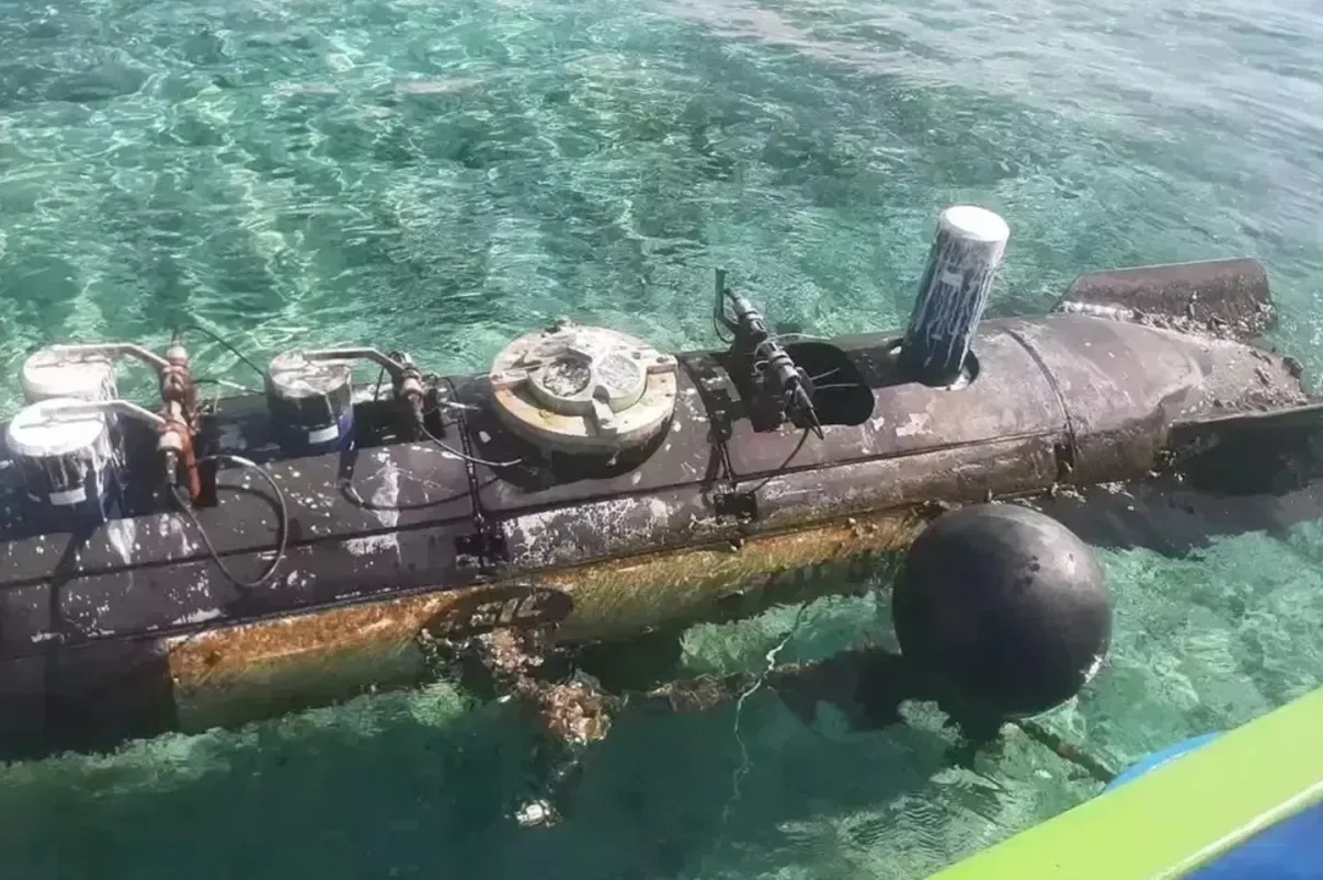
Indonesian authorities are examining a torpedo-shaped unmanned underwater vehicle (UUV) bearing markings from China Shipbuilding Industry Corporation (CSIC) after a fisherman recovered the device near the Lombok Strait on April 6, raising questions about the extent of Chinese underwater data-collection operations across one of the region’s most strategically sensitive maritime corridors.
Ariyanto, 28, found the object floating approximately 10 miles north of Gili Trawangan in West Nusa Tenggara Province at around 10:00 AM local time.
This morning (6/4), a fisherman in Gili Trawangan, West Nusa Tenggara (next to Lombok Strait), found what appears to be a UUV/AUV and brought it ashore. Initial inspection by local authorities found no explosive/radioactive material, but there are Chinese characters and a “CSIC”… https://t.co/Ki6fBS93eD pic.twitter.com/6P4GM80KK8
— JATOSINT (@Jatosint) April 6, 2026
North Lombok police secured the area and called in a Gegana bomb disposal and chemical, biological, and radioactive squad, which conducted a full inspection at 1:00 PM local time.
The team confirmed no explosives or radioactive materials were present. Indonesian authorities transferred the device to Mataram Naval Base at 8:17 PM.
The cylindrical device measures 3.7 meters long and 0.7 meters in diameter, fitted with rear stabilizing fins and a top hatch housing research instrumentation.
It carries CSIC markings alongside the Chinese text “研制” (yán zhì), meaning “developed by.”
🚨🇮🇩🇨🇳Chinese spy drone caught by Indonesian fisherman
Torpedo-shaped UUV found near Gili Trawangan, Lombok Strait
Linked to China’s defense, Indonesian Navy seized it
Likely used for seabed mapping & submarine route intelligence#China #Chinese #ヨックモックの日 #プレバト pic.twitter.com/cKRH73V54m
— Defense24/7 (@Defense247) April 9, 2026
Internal inspection revealed cables, sensors, and an acoustic Doppler current profiler (ADCP), a hydroacoustic instrument that measures water current speed and direction at varying depths.
The Lombok Strait, which separates Bali and Lombok, falls within Indonesia’s Archipelagic Sea Lane II (ALKI II). It is one of the few deepwater corridors in the region capable of accommodating submarines at operational depth while transiting between the Pacific and Indian Oceans.
ADCP data characterizes the current layering and acoustic propagation conditions that submarine operators use to plan stealthy passages through such chokepoints.
5/ An Indonesian fisherman captured a Chinese autonomous underwater vehicle (AUV) in the Lombok Strait.
Preliminary analysis suggests that it was used by the Chinese navy to gather intelligence. pic.twitter.com/qfdaYn1Qox
— Astraia Intel (@astraiaintel) April 7, 2026
Rear Admiral Tunggul, Head of the Navy Information Service, confirmed on April 7 that a technical probe is underway to determine the drone’s origin.
This marks at least the fourth suspected Chinese underwater vehicle recovery in Indonesian waters.
Suspected Chinese UUV found in Indonesia’s strategic Lombok Strait corridor
An underwater unmanned vehicle developed by the 710 Research Institute of China Shipbuilding Industry Corporation was exposed on April 6 while on a mission near the Lombok Strait in Indonesia and was… pic.twitter.com/28N95eYgEt
— Titus Frost 🏴☠️👻 (@ImperatorTruth) April 9, 2026
Fishermen previously retrieved similar devices near the Riau Islands in 2019, the Masalembu Islands in 2020, and off Selayar Island in South Sulawesi in December 2020, the last of which Jane’s analysts confirmed to be a Sea Wing (Haiyi) glider developed by the Shenyang Institute of Automation under the Chinese Academy of Sciences.
Comparable recoveries were documented in the Philippines between 2022 and 2024.